Sea Level and Ocean Heat Content [2025.05.02]
Maps and time series of sea level and ocean heat content (OHC).
- NASA Sea Level Data Analysis Tool ← visualize directly in the browser
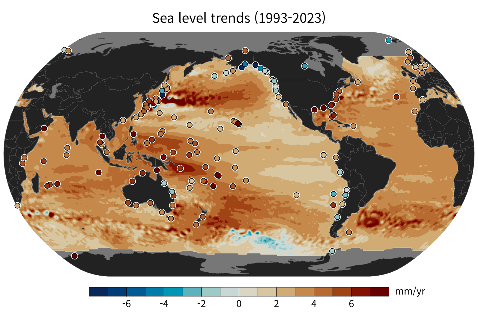
Sea level
AVISO Mean Sea Level
Map & Time series
Altimetry-based global mean sea level (GMSL) rise indicator since 1993
About AVISO Mean Sea Level
Continuous altimetry observations from 1993 to the present have made it possible to establish an important climate indicator: the rise in Global Mean Sea Level (GMSL). Two main factors related to the current global warming explain this GMSL rise: the expansion of the ocean volume and the influx of freshwater from melting ice and glaciers.
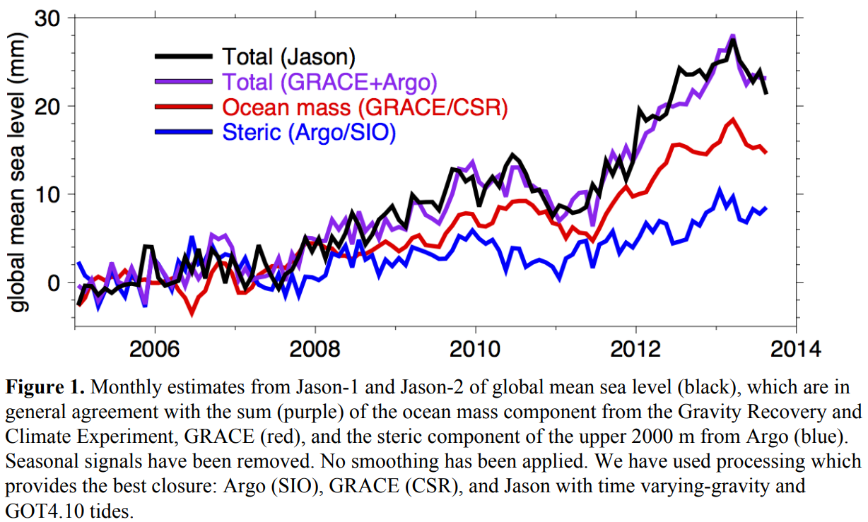
AVISO Barystatic & Manometric SL
Time series
Barystatic and manometric sea level changes from satellite geodesy
Barystatic vs. manometric sea level
Barystatic sea level changes are due to freshwater exchanges with the continents, including ice mass changes from Greenland, Antarctica and continental glaciers, as well as freshwater fluxes from continental areas (i.e. large river basins such as the Amazon).
Manometric sea level changes are due to several processes, including the atmosphere-ocean circulation, sea level fingerprints and the global water cycle.
The product (NetCDF) is open access via the HTTPS server
or non-authenticated FTP (ftp://ftp.aviso.altimetry.fr/pub/oceano/AVISO/indicators/barystatic_manometric/),
under the AVISO licence agreement.
CMEMS Thermosteric Sea Level
0–700 m
Thermosteric sea level anomaly from reanalysis and multi-observation reprocessing
Ocean heat content
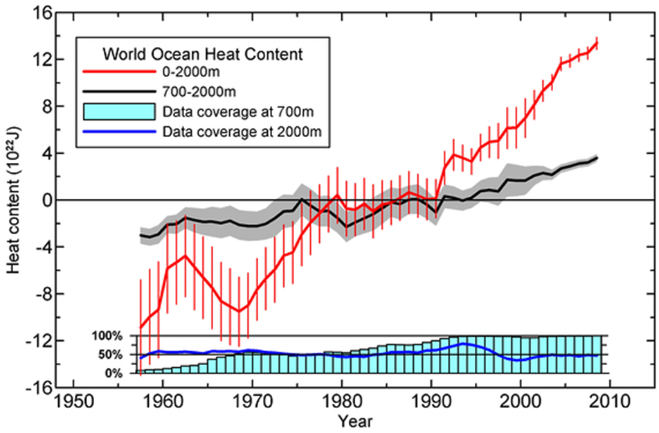
NOAA/NCEI OHC, Salt Content, Sea Level Anomalies
Map & Time series
Computed from in situ data (World Ocean Database) rather than satellites. 0–2000 m, updated quarterly
Ocean Heat Content, Salt Content, and Sea Level Anomalies
Levitus et al. (2012)
About the NOAA/NCEI OHC product
These fields and time series are calculated using in situ temperature and salinity data from the World Ocean Database. Calculations are performed as detailed in Levitus et al. (2012) using the World Ocean Atlas 2009 mean climatological fields for 1955–2006 as a basis for anomaly calculations.
Data distribution figures for temperature and salinity observations, temperature and salinity anomaly fields for depths 0–2000 m, heat content and steric sea level (thermosteric, halosteric, total) are updated quarterly. Temperature anomalies and heat content fields are detailed in World Ocean Heat Content and Thermosteric Sea Level change (0–2000 m), 1955–2010 (publication, pdf). Differences between published work and online values are explained in the comments (pdf), and erroneous values in the notes.
The ocean's thermal expansion due to OHC change directly affects sea level. Calculating OHC from in situ subsurface temperature changes allows researchers to create a corresponding time series, but this is limited by the uncertainty of temperature measurements and the geographic and temporal distribution of subsurface observations.
Salinity anomaly fields indicate changes in the ocean's freshwater budget on shorter time scales (evaporation/precipitation, river discharge, etc.) and longer time scales (transfer of freshwater from continental glaciers). They also measure halosteric change, the saline contraction that affects sea level.
NOAA/NCEI Global OHC CDR
1955–present
Companion to the product above; OPeNDAP access. OHCA time series at 3-monthly, yearly, and pentadal scales
About the Global OHC CDR
The Ocean Heat Content Climate Data Record (CDR) is a set of ocean heat content anomaly (OHCA) time series for 1955–present on 3-monthly, yearly, and pentadal (five-yearly) scales. It provides time series for multiple depth ranges in the global ocean and each of the major basins (Atlantic, Pacific, and Indian) divided by hemisphere (Northern, Southern).
AVISO OHC change & Earth Energy Imbalance
Time series
An alternative OHC-change estimate based on altimetry and gravimetry
About AVISO OHC change & EEI
The OHC change can be estimated directly from net ocean surface heat fluxes measured by CERES, from in situ Argo data, or from ocean model reanalyses. AVISO estimates the OHC change with an alternative method based on space altimetry and gravimetry, which complements these approaches and is promising for reducing uncertainty.
The NetCDF product is open access via the HTTPS server
or non-authenticated FTP (ftp://ftp.aviso.altimetry.fr/pub/oceano/AVISO/indicators/OHC_EEI/global_OHC_EEI/),
under the AVISO licence agreement.
See also Ocean Heat Content and Earth Energy Imbalance.
IAPv4
Ocean temperature & OHC gridded
Cheng et al. (2024)
ESSD paper
Temperature (doi:10.12157/IOCAS.20240117.002)
OHC (doi:10.12157/IOCAS.20240117.001)
IAP Ocean
RFROM
PMEL
Ocean heat content anomaly (OHCA) maps produced from profile data with random-forest regression. Described on the In Situ page